






Exploring the Future of Underwater Surveying with AI and Autonomous Systems
Understanding what lies beneath the surface of our oceans, rivers and coastal infrastructure has always been a challenge. Traditional underwater inspections often can be risky, require specialised equipment, significant fieldwork and time-consuming manual analysis. As organisations look for more efficient ways to monitor marine environments, artificial intelligence (AI) and robotics are creating new possibilities.
A collaborative approach to innovation
The project combines expertise from Griffith University, The University of Queensland, Queensland University of Technology, the University of the Sunshine Coast, KJR and Cyborg Autonomy, the organisation responsible for developing the underwater drone platform used throughout the project.
Using AI to analyse underwater environments
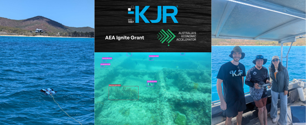
At the core of the project is a computer vision system designed to analyse underwater images and video captured by remotely operated vehicles, while supporting the longer-term vision of autonomous underwater surveying. Instead of relying solely on manual review, the system is being trained to automatically identify and classify objects and features within underwater environments.
- Debris
- Humans
- Immobile creatures
- Mobile creatures
- Infrastructure
- Hard corals
- Plants and soft corals
- Seacraft
- Sea-floor and rock environments
- Wrecks and ruins
The project team is developing what is known as a cascading model architecture. In this approach, an initial model identifies broad categories before passing detections to specialised models capable of providing more detailed classifications. This layered approach has the potential to improve both efficiency and accuracy as the system evolves.
KJR's contribution to the project
KJR is contributing AI and computer vision expertise to the project, including developing training pipelines, preparing datasets and refining the models used to analyse underwater imagery. The team is also supporting collaboration between industry and academia to help translate research outcomes into practical applications.
An important part of the project involves working with university students, who contribute to dataset preparation, image annotation and model experimentation under industry supervision. This provides valuable hands-on experience while supporting the project’s ongoing research and development activities.
The project has also explored the use of KJR’s Geo Video Annotator (GVA), which can connect video footage with location data to support more context-rich analysis of marine environments and infrastructure assets.
Potential applications across marine environments
Although the project remains under active development, the AI model already provides a foundation for several promising applications. The model is built around ten classes of underwater objects and conditions, which Corey Cartmill, KJR’s Computer Vision Tech Lead, explains opens up further opportunities:
This project establishes a foundation for a range of underwater surveying and monitoring applications. Each of the ten classes offers opportunities for further development in a cascading model architecture. Potential applications include monitoring debris, surveying wildlife and coral health assessments. This provides a flexible framework that can be adapted to address a variety of marine research and environmental monitoring needs.
Corey Cartmill, Computer Vision Tech Lead
Supporting marine biosecurity
Monitoring for invasive species is a significant challenge across Australia’s waterways and coastal environments. AI-assisted underwater surveying could help identify organisms or anomalies that warrant further investigation, supporting faster and more targeted biosecurity responses. Rather than replacing expert judgement, the technology is intended to help prioritise where attention is needed most.
Environmental monitoring and conservation
The project is also exploring opportunities to support environmental and conservation initiatives. Potential use cases include coral growth monitoring, coral bleaching assessment and broader marine habitat surveys. By helping researchers process larger volumes of imagery and video, AI could contribute to more efficient long-term monitoring programs.
Infrastructure inspection
Underwater infrastructure requires ongoing monitoring to assess condition and identify emerging issues. The project is investigating how computer vision can assist with detecting biofouling, including the build-up of barnacles and oysters, as well as identifying potential structural concerns. These capabilities may provide valuable support for ports, infrastructure operators and asset managers responsible for underwater assets.
Learning through real-world testing
Field testing has been conducted across a variety of Queensland marine and coastal environments, including reef locations off the coast of Moreton Island, sites around Redcliffe and waterways associated with the Brisbane River and Port of Brisbane. These locations have provided valuable imagery and video datasets to support model development, testing and evaluation.
These real-world activities have highlighted both the opportunities and challenges associated with underwater surveying, including changing visibility conditions, environmental variability and the complexity of obtaining high-quality marine datasets. Each field deployment helps refine both the technology and the team’s understanding of practical operational requirements.
Looking ahead
The AEA Ignite AUV Project demonstrates how collaboration between universities, industry partners and technology specialists can help address complex marine challenges.
Connect with KJR to discuss emerging applications and innovation opportunities in your sector.