Feral-AI

Feral Animal Detection using Drones & Artificial Intelligence

Feral animals pose a significant threat to ecosystems, agriculture, and native wildlife. Their unchecked populations can lead to extensive environmental degradation, economic loss, and the displacement or extinction of native species. Addressing this issue requires precise and efficient methods to monitor and manage these populations.

KJR provides a cutting-edge and scientific approach to survey activities using our expertise in advanced technologies. Our solution integrates drone technology and artificial intelligence to offer comprehensive and efficient surveys that surpass traditional human methods.

You’ve collected the data but are now faced with hours of manual review and analysis? We can help you – we’ll use our advanced AI and ML technologies to efficiently, securely and accurately report on your data – saving you time and resources. Talk to us.

Capability statement

Feral-AI

KJR specialises in leveraging cutting-edge technologies, such as drones, AI, machine learning (ML), and data analytics, to provide innovative, efficient, and precise solutions for environmental management, industry operations, and cultural preservation through its Remote Data Technologies service. This capability statement outlines KJR’s expertise in delivering innovative, data-driven technologies that support landholders, ranger groups, and government agencies in managing native and invasive species more effectively.

Services

Feral-AI Monitoring

KJR’s Feral-AI monitoring involves flying thermal drones over survey areas and processing the images through our proprietary FeralAI software. This software identifies and categorises animals by species, ensuring a reliable and scientifically accurate assessment. The programmed and repeatable flight paths add to the reliability of the data collected.

expertise

Machine Learning and AI

KJR has a long-standing history in technology and innovation. Founded in 1997, we are a 100% Australian-owned technology business with 27 years of experience in software testing, quality assurance, AI, and IT services. Our team leverages advanced AI and machine learning techniques to enhance our image classification models continuously.

FERAL AI

Our Approach

KJR intends to take a cutting edge, scientific approach using our expertise in advanced technologies. 

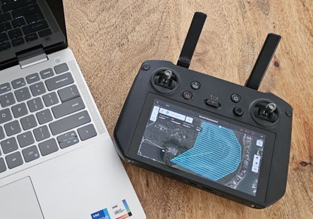
• Drone Technology: Our drones cover large survey areas more efficiently than humans, enabling extensive and thorough monitoring.

 Automated Flight Routes: These routes allow surveys to be repeatable with GPS accuracy down to a few centimetres, ensuring consistent data collection.

 Thermal Imaging: This technology is particularly effective for identifying animals at night, providing a significant advantage over visual spectrum surveys.

A controller next the laptop
Data Expertise

Precise Data Collection

KJR’s drone technologies offer automated mission planning processes that generate precise waypoint missions. These missions define the specific route the drone will follow during its flight, ensuring optimal video capture while maintaining safe operating parameters. The drone’s flight path, heading, gimbal angle, zoom level, and distance to the façade are all taken into account, resulting in high-quality video footage of the desired area. This precise data collection capability is valuable in identifying the subject animals.

Mobile solutions

We work as remote as you are

No matter where you need help, KJR can get there. We’ve developed supporting technology infrastructure which allows us to work off-grid to monitor, capture and communicate data feeds for analysis.

We’ve successfully completed extensive projects already where taken-for-granted phone, power, and internet connections simply don’t exist. 

Picture of the Drones using by KJR in FeralAI

Drone dock on trolley

Night vision picture of animals by FeralAI
AI & MACHINE LEARNING

KJR's Feral-AI Software

After each survey, the KJR team conducts a thorough analysis using AI and image recognition software models. This process provides an objective and scientific basis to:

• Quantify the problem and offer accurate population estimates.

• Identify fauna hot-spots and areas of concern.

• Measure the effectiveness of regeneration or eradication programs.


Designed for Remote Operations

KJR's AI/Data Vehicle

Meet KJR’s mobile data collection vehicle: an all-terrain powerhouse designed to bring AI-powered drone technology directly to the field. Purpose-built for remote operations, this vehicle serves as a mobile command centre equipped with cutting-edge tools to capture, process, and analyse data. Fully equipped with autonomous drones and satellite connectivity, it represents KJR’s commitment to delivering smart, scalable solutions wherever they’re needed most.

Get In Touch