


Transforming Data Collection with AI, Machine Learning & Autonomous Drones
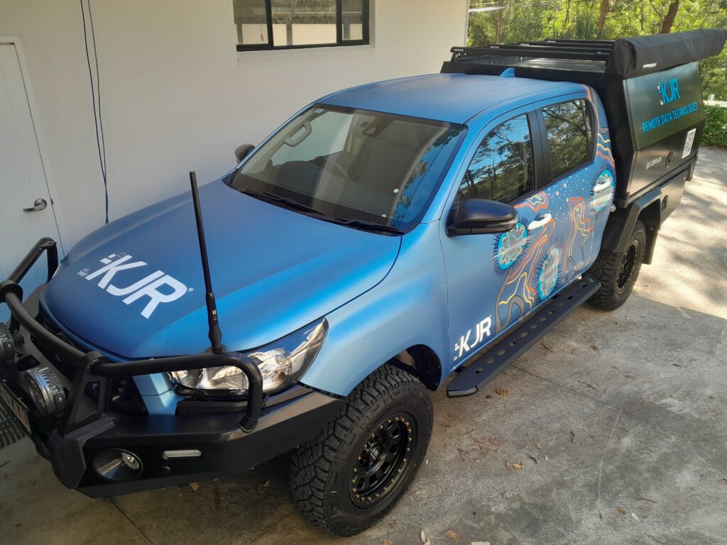
Meet KJR’s mobile data collection vehicle: an all-terrain powerhouse designed to bring AI-powered drone technology directly to the field. Purpose-built for remote operations, this vehicle serves as a mobile command centre equipped with cutting-edge tools to capture, process, and analyse data. Whether it’s monitoring infrastructure, supporting environmental conservation, or aiding in disaster response, the vehicle enables on-the-ground decision-making in even the most isolated locations. Fully equipped with autonomous drones and satellite connectivity, it represents KJR’s commitment to delivering smart, scalable solutions wherever they’re needed most.

Indigenous Artwork
Explore the Story Behind the Artwork
KJR supports Indigenous communities by leading and participating in initiatives that enhance access to education, foster cultural preservation, and create meaningful economic opportunities, as seen in the projects referenced below.
The artwork featured on this vehicle is a contemporary interpretation, traditional West Yalanji design, created by First Nations artist Jedess Hudson. This powerful visual blends Indigenous cultural symbolism with modern themes, such as technology, and connectivity.
Utilising KJR’s brand colours the piece highlights a connection between nature and technology (ancient and modern) through the depiction of a neural network linking nodes representative of KJR’s values and missions; technology, human, community, learning and explorer and juxtaposed against elements connected to earth.
The design reflects the artist’s heritage and highlights the use of technology, like AI and drone mapping to preserve Indigenous knowledge and cultural sites in Far North Queensland.
Elevated Intelligence
AI-Powered Remote Data Technologies
KJR empowers field operations across Australia through intelligent, autonomous, and fully integrated data solutions. From real-time monitoring in disaster zones to predictive analytics in infrastructure maintenance, our AI-driven systems allow accurate, fast, and safe decision-making – wherever the need arises.

Remote Data Technologies
What We Deliver
KJR combines autonomous drones with cutting-edge AI and machine learning to redefine how data is captured, processed, and used in the real world. Our solutions support industries such as infrastructure, environmental science, mining, and disaster response by delivering real-time insights with precision, safety, and speed.
AI-enhanced Autonomous Drone Surveys: LiDAR, thermal, and multispectral imaging for remote inspection
Machine Learning Analytics: Detects patterns, predicts risks, and automates insights
Remote Operations: Operable even in remote, off-grid locations via Starlink satellite connectivity
Secure & Scalable: ISO-compliant data handling, fit-for-purpose solutions adaptable to various industries
KJR’s AI/Data vehicle and Remote Data Technologies capabilities are designed for:
Infrastructure & Utilities
Environmental Monitoring
Disaster Response & Recovery
Agriculture & Land Management

KJR’s mobile vehicle solution enables on-the-ground insights in the most isolated terrains.
Mobile solutions
We work as remote as you are
No matter where you need help, KJR can get there. We’ve developed supporting technology infrastructure which allows us to work off-grid to monitor, capture and communicate data feeds for analysis.
We’ve successfully completed extensive projects already where taken-for-granted phone, power, and internet connections simply don’t exist.

Key Projects
Drones & AI in Action
Feral-AI service
KJR’s Feral-AI service is an autonomous, AI-powered monitoring system that detects and records feral animal activity such as pigs, rabbits, and wallabies, using drones, sensors, and edge analytics. It delivers real-time, geotagged insights in remote areas to support land management, conservation, and invasive species control efforts.
Rock Art Data Capture
A partnership dedicated to rediscovering, documenting, and preserving ancient Aboriginal rock art in Far North Queensland. By leveraging drones, AI, and mapping technologies, we’re helping to build a comprehensive digital archive of these culturally significant sites.
Goondoi Rangers
KJR provides drone certification and data training to Goondoi Rangers to enhance their capabilities in wildlife tracking, fire control, and land management. In partnership with Radiant Life College, we also support STEM education for Indigenous youth through our RPAS engagement program, giving students hands-on experience with drone and AI technologies.
Marine Debris Task Force
In collaboration with Salty Monkeys, KJR is addressing the pressing issue of marine debris, particularly ghost nets in the Torres Strait. This initiative combines community involvement with cutting-edge technology to protect marine ecosystems.
Take Your Data to New Heights with KJR
At KJR Remote Data Technologies, we redefine how businesses collect, analyse, and leverage data. With AI-enhanced drone solutions, cutting-edge machine learning, and intelligent data management, we enable organisations to gain real-time, high-precision insights that drive smarter, faster, and safer decision-making.
📞 Contact Us Today to discover how KJR’s AI-powered remote data solutions can transform your operations!